


countryside

icone_mesure
slug
countryside

Measurement_577f378c-75d0-40aa-a062-8242865be561

Measured radiation

0.206 µSv/h
geolocalisation :

46.0009633, 3.580835

Ground level
Atomic Tessoss
ATYPICAL MEASURE
Date de la mesure :
Latitude :
46.0009633
Longitude :
3.580835
Altitude (M) :
374.0
Measurement time :
1 minutes 36 secondes
Distance travelled :
0.00m
Measurement speed :
Measurement Environment :
En campagne countryside
Weather :
Tags :
Description :
Temperature :
17.0°C
Hits number :
51
Mesure UUID :
577f378c-75d0-40aa-a062-8242865be561
Manual Reporting :
No
Sensor / ID :
6C:30:2A:3F:22:F2
Sensor / Firmware version :
AtomTag
Sensor / Type :
Sensor / Tube type :
SBM-20
Smartphone / UUID :
2355096de2553836
Smartphone / Platform :
android
Smartphone / Model :
2311DRK48G
Smartphone / OS Version :
14
Position acurracy :
4.9
Measurement height above the ground (in meters) :
1.00
Altitude accuracy :
4.9
Mean qualification :
Ground level
Software version :
OpenRadiation app 3.1
Measured value :
0.206 µSv/h
Measurement_89aab542-aefd-4c5f-87c3-bb806b643dc2

Measured radiation

0.038 µSv/h
geolocalisation :

16.205247746121, -61.605489276852

Ground level
Date de la mesure :
Latitude :
16.205247746121
Longitude :
-61.605489276852
Altitude (M) :
6.0
Measurement time :
5 minutes 1 secondes
Distance travelled :
74.45m
Measurement speed :
Measurement Environment :
En campagne countryside
Weather :
Tags :
Description :
Temperature :
24.0°C
Hits number :
51
Mesure UUID :
89aab542-aefd-4c5f-87c3-bb806b643dc2
Manual Reporting :
No
Sensor / ID :
D311C197-1EDD-7E2A-B324-EB0AB9D99214
Sensor / Firmware version :
AtomTag
Sensor / Type :
Sensor / Tube type :
SBM-20
Smartphone / UUID :
E97BA695-C93E-45EF-A41E-3A1C2BB3540C
Smartphone / Platform :
ios
Smartphone / Model :
iPhone14,7
Smartphone / OS Version :
18.6.2
Position acurracy :
33.1
Measurement height above the ground (in meters) :
1.00
Altitude accuracy :
33.1
Mean qualification :
Ground level
Software version :
OpenRadiation app 3.1.1
Measured value :
0.038 µSv/h

Measurement_82f9245b-3a6f-4af0-9a8a-99282af28a8f

Measured radiation

0.096 µSv/h
geolocalisation :

-42.7242049, -70.5304926

Ground level
ileva
Date de la mesure :
Latitude :
-42.7242049
Longitude :
-70.5304926
Altitude (M) :
529.0
Measurement time :
1 heures 29 minutes 28 secondes
Distance travelled :
0.70m
Measurement speed :
Measurement Environment :
En campagne countryside
Weather :
Tags :
Description :
Temperature :
11.0°C
Hits number :
1583
Mesure UUID :
82f9245b-3a6f-4af0-9a8a-99282af28a8f
Manual Reporting :
No
Sensor / ID :
6C:30:2A:3F:1B:F4
Sensor / Firmware version :
AtomTag
Sensor / Type :
Sensor / Tube type :
SBM-20
Smartphone / UUID :
01755d479d29b69b
Smartphone / Platform :
android
Smartphone / Model :
CPH2791
Smartphone / OS Version :
16
Position acurracy :
14.2
Measurement height above the ground (in meters) :
1.00
Altitude accuracy :
14.2
Mean qualification :
Ground level
Software version :
OpenRadiation app 3.1
Measured value :
0.096 µSv/h

Measurement_be898587-62a2-456a-b11f-575938a065d2

Measured radiation

0.110 µSv/h
geolocalisation :

-21.224005487767, 55.692080743663

Ground level
FQopenrad
Date de la mesure :
Latitude :
-21.224005487767
Longitude :
55.692080743663
Altitude (M) :
2218.0
Measurement time :
3 minutes 38 secondes
Distance travelled :
1.96m
Measurement speed :
Measurement Environment :
En campagne countryside
Weather :
Tags :
Description :
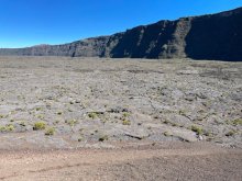
piton de la fournaise - For’ica Meo
measurment image
Temperature :
19.0°C
Hits number :
71
Mesure UUID :
be898587-62a2-456a-b11f-575938a065d2
Manual Reporting :
No
Sensor / ID :
A5994590-892F-A76E-BE8F-17984B9ED805
Sensor / Firmware version :
AtomTag v.1.0.3
Sensor / Type :
Sensor / Tube type :
SBM-20
Smartphone / UUID :
A68BE50F-1387-4AFB-979C-8E9B20E239D3
Smartphone / Platform :
iOS
Smartphone / Model :
iPhone13,2
Smartphone / OS Version :
17.5.1
Position acurracy :
3.5
Measurement height above the ground (in meters) :
Altitude accuracy :
3.5
Mean qualification :
Ground level
Software version :
OpenRadiation app 2.3.4
Measured value :
0.110 µSv/h

Measurement_083ee117-48b8-4193-a0dc-03daf110a35a

Measured radiation

1.396 µSv/h
geolocalisation :

37.3738958, 140.9948656

Ground level
Sydykova Alila
ATYPICAL MEASURE
Date de la mesure :
Latitude :
37.3738958
Longitude :
140.9948656
Altitude (M) :
62.0
Measurement time :
21 secondes
Distance travelled :
1.11m
Measurement speed :
Measurement Environment :
En campagne countryside
Weather :
Tags :
Description :
Temperature :
17.0°C
Hits number :
68
Mesure UUID :
083ee117-48b8-4193-a0dc-03daf110a35a
Manual Reporting :
No
Sensor / ID :
18:45:16:97:89:FE
Sensor / Firmware version :
AtomTag
Sensor / Type :
Sensor / Tube type :
SBM-20
Smartphone / UUID :
1b13fe0c400d8e86
Smartphone / Platform :
android
Smartphone / Model :
SM-A155F
Smartphone / OS Version :
16
Position acurracy :
17.3
Measurement height above the ground (in meters) :
1.00
Altitude accuracy :
17.3
Mean qualification :
Ground level
Software version :
OpenRadiation app 3.1
Measured value :
1.396 µSv/h

Measurement_2f4d9441-ed9f-4f4f-80fc-1e47f052567e

Measured radiation

1.179 µSv/h
geolocalisation :

37.3738967, 140.9948781

Ground level
Sydykova Alila
ATYPICAL MEASURE
Date de la mesure :
Latitude :
37.3738967
Longitude :
140.9948781
Altitude (M) :
63.0
Measurement time :
46 secondes
Distance travelled :
0.00m
Measurement speed :
Measurement Environment :
En campagne countryside
Weather :
Tags :
Description :
Temperature :
17.0°C
Hits number :
121
Mesure UUID :
2f4d9441-ed9f-4f4f-80fc-1e47f052567e
Manual Reporting :
No
Sensor / ID :
18:45:16:97:89:FE
Sensor / Firmware version :
AtomTag
Sensor / Type :
Sensor / Tube type :
SBM-20
Smartphone / UUID :
1b13fe0c400d8e86
Smartphone / Platform :
android
Smartphone / Model :
SM-A155F
Smartphone / OS Version :
16
Position acurracy :
20.1
Measurement height above the ground (in meters) :
1.00
Altitude accuracy :
20.1
Mean qualification :
Ground level
Software version :
OpenRadiation app 3.1
Measured value :
1.179 µSv/h

Measurement_9ee92d6a-8c60-45f5-b59c-e3a91f7eb909

Measured radiation

1.369 µSv/h
geolocalisation :

37.3738967, 140.9948781

Ground level
Sydykova Alila
ATYPICAL MEASURE
Date de la mesure :
Latitude :
37.3738967
Longitude :
140.9948781
Altitude (M) :
63.0
Measurement time :
46 secondes
Distance travelled :
0.00m
Measurement speed :
Measurement Environment :
En campagne countryside
Weather :
Tags :
Description :
Temperature :
17.0°C
Hits number :
140
Mesure UUID :
9ee92d6a-8c60-45f5-b59c-e3a91f7eb909
Manual Reporting :
No
Sensor / ID :
18:45:16:97:89:FE
Sensor / Firmware version :
AtomTag
Sensor / Type :
Sensor / Tube type :
SBM-20
Smartphone / UUID :
1b13fe0c400d8e86
Smartphone / Platform :
android
Smartphone / Model :
SM-A155F
Smartphone / OS Version :
16
Position acurracy :
20.1
Measurement height above the ground (in meters) :
1.00
Altitude accuracy :
20.1
Mean qualification :
Ground level
Software version :
OpenRadiation app 3.1
Measured value :
1.369 µSv/h

Measurement_09d4ff02-71f2-4aea-9c1c-2aad58237f07

Measured radiation

0.300 µSv/h
geolocalisation :

37.38484573356, 140.87652888085

Ground level
ATYPICAL MEASURE
Date de la mesure :
Latitude :
37.38484573356
Longitude :
140.87652888085
Altitude (M) :
589.0
Measurement time :
6 minutes 11 secondes
Distance travelled :
144.60m
Measurement speed :
Measurement Environment :
En campagne countryside
Weather :
Tags :
Description :
Temperature :
25.0°C
Hits number :
251
Mesure UUID :
09d4ff02-71f2-4aea-9c1c-2aad58237f07
Manual Reporting :
No
Sensor / ID :
Sensor / Firmware version :
Bertin RadConnect v1.0.1969
Sensor / Type :
Sensor / Tube type :
J305γβ
Smartphone / UUID :
125F735D-01F0-4023-B4B8-69B2018E323E
Smartphone / Platform :
ios
Smartphone / Model :
iPhone17,1
Smartphone / OS Version :
18.7
Position acurracy :
4.7
Measurement height above the ground (in meters) :
0.00
Altitude accuracy :
4.7
Mean qualification :
Ground level
Software version :
OpenRadiation app 3.1.1
Measured value :
0.300 µSv/h

Measurement_5df91884-325c-4d7e-8fd6-6a778d7c3871

Measured radiation

0.130 µSv/h
geolocalisation :

0, 0

Ground level
Kumamon
Date de la mesure :
Latitude :
0
Longitude :
0
Altitude (M) :
0.0
Measurement time :
2 minutes 26 secondes
Distance travelled :
Measurement speed :
Measurement Environment :
En campagne countryside
Weather :
Tags :
Description :
Osaka Hattori Ryokuchi,
Temperature :
25.0°C
Hits number :
50
Mesure UUID :
5df91884-325c-4d7e-8fd6-6a778d7c3871
Manual Reporting :
No
Sensor / ID :
F1-59
Sensor / Firmware version :
RiumGM
Sensor / Type :
Sensor / Tube type :
J305γβ
Smartphone / UUID :
Smartphone / Platform :
Android
Smartphone / Model :
Sony XQ-CC54
Smartphone / OS Version :
14.0
Position acurracy :
Measurement height above the ground (in meters) :
1.00
Altitude accuracy :
Mean qualification :
Ground level
Software version :
RiumApp 3.3.6
Measured value :
0.130 µSv/h

Measurement_d2a34957-1339-46d2-bb0f-13ad7d969692

Measured radiation

0.012 µSv/h
geolocalisation :

22.0295014, -29.8493811

Ground level
Date de la mesure :
Latitude :
22.0295014
Longitude :
-29.8493811
Altitude (M) :
20.0
Measurement time :
5 minutes 4 secondes
Distance travelled :
762.85m
Measurement speed :
Measurement Environment :
En campagne countryside
Weather :
Tags :
Description :
Temperature :
60.0°C
Hits number :
52
Mesure UUID :
d2a34957-1339-46d2-bb0f-13ad7d969692
Manual Reporting :
No
Sensor / ID :
00161
Sensor / Firmware version :
OpengKIT71
Sensor / Type :
Sensor / Tube type :
SBM-20
Smartphone / UUID :
6263514571906960
Smartphone / Platform :
Android
Smartphone / Model :
2109119DG
Smartphone / OS Version :
12
Position acurracy :
20.5
Measurement height above the ground (in meters) :
0.00
Altitude accuracy :
20.5
Mean qualification :
Ground level
Software version :
OpenRadiation app 2.3.4
Measured value :
0.012 µSv/h